AROUND KUSADASI
Kusadasi
Didyma
Pamukkale
Izmir
Selcuk
Miletus
Sirince
Kusadasi
You'll never regret
including the popular resort town of Kuşadası in your itinerary when
you are planning your holidays to Turkey as this tourist destination
along Turkey's Aegean coast boasts of numerous fine sandy beaches as
well as being a favorite port of call for cruise ships who operate
in the area. Kuşadası is a charming resort town with a rich,
colorful history and some of the old houses along the picturesque
harbor and the waterfront have been converted into cozy bars and
restaurants to cater to the multitudes of tourists who come over to
visit from various cruise ships.
As well as the ancient cities surrounding Kuşadası, it is an
important coastal city in it's own right and has it's own historical
structures.You can truly walk in the footsteps of history when you
visit it's historical buildings, shop in traditional bazaars and
enjoy the peace, tranquillity and ancient craftsmanship on view at
it's splendid mosques.
Port and Marina
Kuşadası Gulf widens
towards the South towards the beaches and gulfs of the Aegean.
Kuşadası Gulf always has ships, yachts and cruise ships passing
through.Historical places,natural beauties,old fashioned narrow
streets for shopping, the temperate climate and the cultural
acilities contribute to the vivacity of this cosmopolitan city.
Kuşadası Gulf is also very appropriate for swimming,and both diving
and skin-diving with its unique beaches, clean water and secluded
bays.On the route marvellous hotels,tea gardens and fish restaurants
are awaiting you between the view of mountains and crystal sea water.
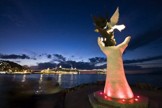
Kuşadası port is one of the most important components of local
tourism.It is serviced by two wharves respectively 264 and 255
meters long and has the capacity of ship acceptance of 2400 ships
per year.The port serves Cruise ships and other boats.The arrival of
these ships is an indispensable part of Kusadasi's tourism as the
ships bring day trippers, and creates a most important share to the
economical activities in the county.
Shopping
Kuşadası is defined as a 'Paradise of shopping'
please be asssured that this is not an
exaggeration.You can find a range of good
quality souvenirs including leather products,
from a choice of over four thousand shops.
Kuşadası port is an important stop of for the
Cruise ships and has it's own well appointed
shopping centre.
Kuşadası is an ideal holiday destination and offers seafood and other restaurants,cafes,parks and marvellous beaches.Shopping is a famous qualification of this area with it's hand tooled leather products,fabulous jewellery and collectible carpets. Kuşadası bazaar ,Ladies Beach and the bars, nightclubs and restaurants around the marina provide a colourful ambiance.
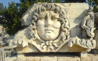
Didyma is located near the village of Yenihisar (Yoran) near the town of Söke in the province of Aydın in the Aegean region. Here one finds an important sanctuary that housed one of the oracles of Apollo. It was connected to Miletus by sea, and those arriving by ship would land at the harbour of Panormus and thence follow the Sacred way to Didyma. Until its destruction by the Persians in 494 B.C. it was administered by the family of the Branchidae, the descendants of Bronchos, a youth beloved of Apollo. For the last two kilometers the Sacred Way was lined with seated statues of the male and female members of the Branchidae family. After his capture of Miletus in 334 B. C. Alexander the Great placed the administration of the oracle in the hands of the city of Miletus. In 331 B.C. the oracle proclaimed Alexander "the son of Zeus". In 300 B.C. the Milesians embarked on the construction of the largest temple in the Greek world. Although work continued until the middle of the 2nd century A.D. the temple was never finished. Later, a church and other buildings were constructed, while the Byzantines built a barracks in which troops were garrisoned. The buildings were damaged by fire and in the 15th century further damage was caused by a great earthquake. The Temple of Apollo (Didymaion) was the largest and wealthiest Ionic temple in Anatolia and was renowned for its holy relics, its treasury, its sacred spring and sacred laurel grove. Investigations in the Temple of Apollo were first undertaken in 1834 by the French traveller Charles Texier and the English archaeologist Charles T. Newton, who had conducted the excavations at Halicarnassus.
The first excavations were begun in 1904 by
Theodor Wiegand under the auspices of the Berlin
Museum and continued until 1913. Since 1962
excavations have been conducted by Klaus Tucheld
on behalf of the German Archaeological Institute.
The first Temple of Apollo was built in the
Archaic period and the Hellenistic temple which
succeeded this was built on the foundations of
the earlier building, materials from which were
used in the construction. The temple we see
today is an Ionic structure measuring 60 x 118
m, with a dipteral arrangement of two rows of
columns with 21 on each side and 10 at each end.
The columns are of various styles with pedestals
adorned with reliefs. These columns support an
architrave surmounted by a frieze decorated with
acanthus leaves and Gorgon (Medusa) heads. The
high pronaos at the top of a monumental flight
of steps leads into a naos with two columns,
which gives access to the sacred area or cella
in the form of an open courtyard surrounded by
high walls with columns and containing a small
Ionic temple which housed the statue of the god.
Didyma was never a large city and its fame was
closely connected with the existence of a sacred
spring and the temple founded over it. The
ancient Greeks merely took over the already
existing sanctuary and reorganised it.
Didyma was
connected to Miletus by the Sacred Way, the
latter part of which was lined with sarcophagi
and statues of lions and sphinxes. The
Branchidae family was responsible for the
maintenance of the Sacred Way.
The remains of the earliest temple, which lie
within the later building, have been dated to
the 8th and 7th centuries B.C. These consist of
a sacred wall measuring approximately 24 x 10 m,
an open-air sanctuary, a portico 16 m in length,
a sacred well and a votive altar.
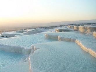
Pamukkale
Until
forty or fifty years ago, Pamukkale was a place
where travelers who happened to pass by found
peace and tranquillity and the opportunity for
quiet meditation by the side of the sacred
spring that still lies exposed, amid the few
ancient columns and in the deep silence of the
tombs that lay scattered over the countryside to
the west and extended out towards the
surrounding hills. In spite of the doubtful
merits of present-day developments, and in spite
of all the ugly building construction that has
taken place, the seething crowds, the noise and
pollution, one can still confidently assert that
Pamukkale has lost nothing of its former
attractions.
Pamukkale is located in the Inner Aegean region
at a distance of 20 km from the town of Denizli.
This lovely, rapidly developing district in the
Menderes valley, which enjoys a temperate
climate over the greater part of the year, has
all the conditions required for an ideal
touristic resort.The tectonic movements that
took place in the fault depression of the
Menderes river basin gave rise to the emergence
of a number of very hot springs, and it is the
water from one of these springs, with its large
mineral content, chalk in particular, that has
created the natural wonder now known as
Pamukkale, Cotton Fortress or Baumwollenschloss,
a very appropriate name for such a phenomenon...
You may
approach Pamukkale by the main roads marked on
your map, but there are also other ways,
according to the direction from which you are
coming. For example, if you approach from the
West you can branch off to the left at the sign
shortly after Sarayköyü.This will give you the
opportunity of seeing and getting to know quite
a few very interesting Western Anatolian
villages.On approaching Pamukkale, whether you
choose the route through these villages or
arrive by the Denizli road you will be
confronted by one of the most remarkable
landscapes to be seen anywhere in Turkey.The
first thing you will see is a rock platform over
100 m in height rising up from the plain. The
slopes of this hill, which look from a distance
like a great white speck, are covered with large
numbers of pools and terraces.As you come nearer,
you will begin to see this natural phenomenon,
which resembles a frozen waterfall, in greater
detail.
From the edge of every terrace and every step in
this fascinating natural phenomenon that has
gradually formed throughout the ages hang
brilliantly white stalactites, and you can hear
the joyful splashing of the waters of the hot
springs as they cascade down over slopes where
their flow is impeded only by clumps of
oleanders.The temperature of the water forming
the travertines, which issues from the hot
springs on the hills above, falls to around 33
C° lower down.On emerging to the surface, the
solution of calcium-carbonate in the spring
water decomposes into carbon dioxide, calcium
carbonate and water. The carbon dioxide is
released into the air while the calcium
carbonate separates off from the water to form a
grayish-white limestone sediment.The beds of the
water-courses are filled up with these limestone
deposits and the water, confronted with these
obstacles, splits up into several branches.The
water flows over the slopes into pools, the
small basins surrounding them and finally into
the fields below.It is in this way that these
terraces over 100 m in height composed of layers
of the accumulated limestone sediment have been
gradually formed in the course of the ages. As
the limestone sediment reaches a certain level
the water accumulates in pools and, as these
pools fill up, overflows into smaller pools in
the vicinity and from these flowsinto the small
hollows and depressions around them.The
limestone layers in the pools rise up in steps,
one above the other, and the continual flow of
water keeps this process in operation.The
stalactites form one of the most important
features in the landscape.
With the formation of the layers and the
emergence of steps and terraces one above the
other, the water leaves the limestone deposit
behind it and drips down in the form of
stalactites, as in the Damlataş caverns.The
calcium oxide in the water adds to the thickness
of the white layers and widens the terraces,
producing pools in fantastic shapes reminiscent
of oyster shells or flower petals, while the
small amount of sulphur and iron oxide produces
stripes of yellow, red and green over the white
of the limestone. Any object left in the water
at Pamukkale will take on a coating of limestone
within a very few days. Now, as in the olden
days, the water flows through open channels, and
in cold weather you can see columns of mist
dancing over the surface.Although the water
flowing from the hot springs on the southern
slopes of Çaldağ rapidly loses heat during its
flow through these open channels it is still hot
enough to make it possible for one to bathe
throughout six months of the year in the open-air
swimming pools in the motels and on the terraces.
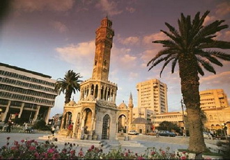
Izmir
is located in the Aegean province, which, of all
the seven geographical regions of Turkey, enjoys
the finest climate. In population it is the
third city in Turkey.It is located in an area
whose magnificent history has made it a tourist
centre. It lies at the centre of the most
important land, air and sea communication
network in the ancient Aegean region.
THE LEGENDARY
ORIGIN OF ITS NAME
The wife of
Cinyras, King of Cyprus, foolishly claimed that
her daughter, Smyrna, was more beautiful than
Aphrodite herself. This so enraged the goddess
that she made Smyrna fall in love with her own
father and one night Smyrna's nurse having made
the king drunk, she climbed into his bed. When
he finally awoke from his drunken slumber, the
king drew his sword and drove his daughter from
the palace, pursuing her into the countryside.Just
as he was about to overtake her and kill her
with his sword, Aphrodite took pity on the girl
and turned her into a myrrh tree.
As it descended, the king's sword split the
myrrh-tree and ADONIS tumbled out. And thus
Adonis was born.
According to famous ancient travelers such as
Aristides, Strabo, Pliny and Pausanias, Izmir
was founded around 1450 B.C. by TANTALUS, King
of Manisa (Spilos) to the north-east of the
present-day city.
There is also a legend to the effect that it was
founded by the Amazons. The one certain thing is
that Izmir is not a Greek word and would appear
to be derived from an autochthonous language.
Selçuk is the central town of Selçuk district, İzmir Province in Turkey, 20 km (12 mi) northeast of Kuşadası, 5 km (3 mi) northeast of Ephesus. Its original name was Ayios Theologos (Greek: Άγιος Θεολόγος), from which the Ottoman Turkish name Ayasluğ is derived. In 1914 it was renamed Selçuk, after the Seljuk Turks who settled in the region in the 12th century. It was a township in Kuşadası district till 1954 and Torbalı between 1954-1957. It finally became a district in 1957. Its neighbours are Torbalı from north, Tire from northeast, Germencik from east, Kuşadası from south, Aegean Sea from west and Menderes (formerly Cumaovası) from northwest.
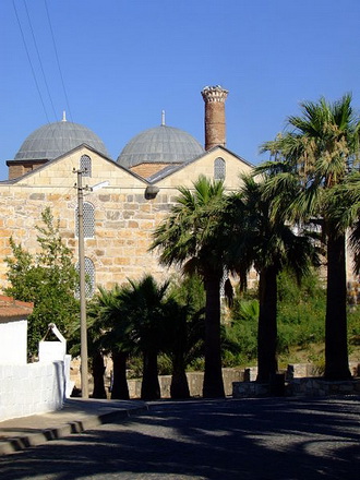
Selçuk
is one of the most visited touristic
destinations within Turkey, known for its
closeness to the ancient city of Ephesus, House
of the Virgin Mary and Seljukian works of art.
The 6th century Basilica of St. John the Apostle,
which, some claim, is built on the site of the
Apostle's tomb, is also inside the town. With
the vast majority of tourists only using Selçuk
as a stopping point for Ephesus and not visiting
the town itself, the old quarter of Selçuk
remains generally undisturbed and undeveloped,
retaining traditional Turkish culture and
locality.
Ayasoluk Hill dominates the surrounding area,
with several historical buildings on its slopes,
including the İsa Bey Mosque built by the Seljuk
Turks in 1375, and the Grand Fortress.
The Ephesus Airport and Selçuk Training Center
of the Turkish Aeronautical Association is only
3 kilometers away from Selçuk, offering piloting,
parachuting, and microlight training.
Situated at the mouth of the Meander in the south of the province of Ionia in Western Anatolia, the ancient city of Miletus was the oldest and the most powerful of the twelve Ionian cities in Asia Minor. It also founded over ten colonies on the shores of the Marmara and the Black Sea, while its commercial activities extended as far as Egypt. Its schools made a very great contribution to the intellectual and scholarly development of the Mediterranean world and one cannot talk of Miletus without mention of the great contributions to geometry and science made by Thales, one of the greatest scholars produced by the city.
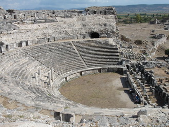
Miletus is also renowned as the first city to which the principles of modern town-planning were applied. The gridplan introduced by Hippodamos was later to form the basis of town-planning in all Roman cities. As a result of the silting caused by the alluvium washed down by the Meander the city now lies at a distance of several kilometres from the sea. The fact that Miletus formerly possessed four separate harbours well indicates the important role played by the Meander in the history of the city.
The village of Sirince
referred in ancient
sources as the Ephesus
on the Mountain suggests
long established
settlement. Although
there seems to be no
concrete indication of
how it came onto the
stage of history, the
dominant theory is that
a small group of people
resettled on the
mountain, following the
fall of the city of
Ephesus and its harbour
being moved to Kusadası
(Scala Nova). The people
might have preferred to
move and settle in the
mountains due to
problems caused by the
silting and the flooding
of the river Meander.
It is told in the
village today that this
new village on the
mountain was called
Cirkince, meaning rather
ugly, with the intention
of drawing less
attention and interest
of outsiders, thus
ensuring security. One
of the principal
anecdote abput naming of
the village tells that a
group of Byzantine
Greeks who were freed
from the dominion of
Aydınogulları and sent
away for re-settlement,
were asked by the
neighbouring villagers
whether the new place
they had settled was
nice or not. The answer
was rather ugly.

The oldest building in
Sirince is from the
Hellenistic period,
initially built as a
tower initially, and
most probably left from
the Lysimakhos era
corresponding to the
time when the city of
Ephesus was established.
It was part of an early
warning system built in
the Klasseas Valley
which was of strategic
military importance. The
building has had some
alterations during the
Byzantine period and is
locally thought to have
been a monastery.
A ceramic seal with the
name of Georgeos used to
brand bread in a bakery
was found in a peach
garden indicating the
existence of a community
life in the region in
the Byzantine period.
The oldest travel notes
about Kirkinca are in
the book of memories
called “A Visit to
Turkey and Return to
Britain”, written by a
scholar priest Edmund D.
Chishull , who lived in
Izmir during 1698-1702.
Leaving Tire, Chishull
reached the ancient city
of Ephesus on April
30,1699. As the book
reveals, the place to
stay for the night
around Ephesus is the
village of Kirkidje.
Chishull and his guide
arrived in the village
at around eight oclock
in the evening tracing
along the Klassen Valley
in the east of Ayasuluk
hill.
Kirkinca was a village
of 1800 households of
Byzantine Greeks during
the Ottoman reign in the
19th century.
World War I started in
1914 with all its
violence in Anatolia.
The Ottoman government
registers the young
Byzantine Greeks of the
Kirkica Village to join
the Worksmen Battalion.
However, those running
away from the battalion
either go to he
mountains to live as a
gang of brigands or took
refuge in Greece to
boycott. Those who could
survive the war return
to their village when
the war ends. Dido
Sotiriyu reflects about
those years in her novel
called Farewell Anatolıa
writing:
The Germans had left
behind their munitions
stores in the ancient
Ephesus. The Turkish
gendarme appointed by
the Mondros Armistice to
hand them over to the
allies had run away.
Following the night fall,
the villagers of
Kirkinca carried all the
weapons and explosive
materials to the village
pacing the roads of
Ephesus. It was then
that they felt
independent. Hunchbacks
immediately became
straight.
On May 15, 1919 the
Greek army occupying
İzmir was welcomed with
excitement in the
village of Kirkica.
Identifying themselves
as Greek, the young
people of Kirkica, Urla,
Bornova and Kusadasi
volunteered to join the
independent regiments
headed by Greek officers.
The Sevr Agreement
signed on 10 August 1920
encouraged these young
people with the hope to
share the eastern
Anatolia with the allies.However,
the success of the Great
Assault ending the
Turkish Independence War,
and the rescuing of
İzmir from the Greek
occupation on 9
September 1922, caused
the Byzantine Greek
villagers of the region
to migrate to Greece.
Kirkica then turned into
a deserted village like
the others, with a few
elderly inhabitants left
behind.
In 1924, a Population
Exchange Agreement was
signed between Turkish
and Greek governments.
Thus,the post-war
Kirkica was revitalized
with Turkish newcomers
from Salonika, Kavala
and Provusta. The words
of Kazim Dirik Pasha,
the governor of İzmir at
the time, about the name
of the village are still
quoted in the region.
During the first years
of the Turkish Republic,
he visited the village
and suggested changing
its name from Cirkince -meaning
rather ugly- to Sirince
meaning charming, saying
such a nice place should
not be called ugly, but
could only be called
pretty.
Natural environment
Sirince stands at the
end of the valley which
goes along the Çirkince
mountain-pass from
Selçuk to the east. The
river flowing in the
valley was called
Klasseas in antiquity.
The mountains in the
north are called Elemen.
Selahattin Mountain is
the current name given
to the hills stretching
to the east. Beylik Hill,
508 meters in height, is
to the west of Şirince,
overlooking the sea and
the Selcuk plain.
The hills around Sirince
are covered with pine
trees and on the rocky
cliffs with scrub.
Marshmallows with violet
flowers are the most
striking plants on the
climb to Şirince. The
town is surrounded by
olive groves, tangerine
and fig gardens, and
vineyards.